The Arctic is defined differently by various domestic and international organizations as well as legal agreements. Some common definitions of the Arctic include (1) the areas above the Arctic Circle (66° 32’N) and (2) areas delineated by the 10-degree isotherm (a line on a map connecting points having the same temperature at a given time or the same mean temperature for a given period). However, both the International Maritime Organization and the Arctic Council have different definitions of the Arctic as outlined below:
The Arctic as defined by the International Maritime Organization
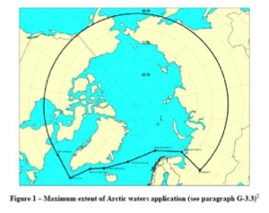 The International Maritime Organization defines Arctic waters as “those waters which are located north of a line extending from latitude 58°00’.0 N, longitude 042°00’.0 W to latitude 64°37’.0 N, longitude 035°27’.0 W and thence by a rhumb line to latitude 67°03’.9 N, longitude 026°33’.4 W and thence by a rhumb line to Sørkapp, Jan Mayen and by the southern shore of Jan Mayen to the Island of Bjørnøya and thence by a great circle line from the Island of Bjørnøya to Cap Kanin Nos and thence by the northern shore of the Asian continent eastward to the Bering Strait and thence from the Bering Strait westward to latitude 60° N as far as Il’pyrskiy and following the 60th North parallel eastward as far as and including Etolin Strait and thence by the northern shore of the North American continent as far south as latitude 60° N and thence eastward along parallel of latitude 60° N, to longitude 56°37’.1 W and thence to the latitude 58°00’.0 N, longitude 042°00’.0 W.”[1]
The Arctic as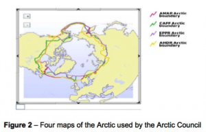 Defined by the Arctic Council
In addition to the International Maritime Organization definition of the Arctic, various Arctic Council bodies have established differing definitions for the Arctic. The Arctic Council is an intergovernmental forum that promotes the cooperation, coordination and interaction among the Arctic States, Arctic indigenous communities and other Arctic inhabitants on common Arctic issues. The definitions of the Arctic developed by various Arctic Council groups vary based on criteria that are relevant to each body’s respective concerns. For example, the Arctic Monitoring and Assessment Program (AMAP) has established a definition of the Arctic that incorporates numerous considerations including the Arctic Circle, political boundaries, vegetation boundaries, permafrost limits, and major oceanographic features.[2] With these criteria in mind, the Arctic region covered by AMAP includes terrestrial and marine areas north of the Arctic Circle (66°32’N), and north of 62°N in Asia and 60°N in North America, modified to include the marine areas north of the Aleutian chain, Hudson Bay, and parts of the North Atlantic Ocean including the Labrador Sea.
The Arctic Council’s Emergency Prevention, Preparedness and Response Working Group (EPPR), the Conservation of Arctic Flora and Fauna (CAFF) Working Group, and the Arctic Monitoring and Assessment Program (AMAP), all have different definitions of the Arctic as detailed in Figure 2.
[1] Resolution A.1024(26) Guidelines for Ships Operating in Polar Waters (December, 2, 2009).
[2] Arctic Monitoring and Assessment Programme, AMAP Assessment Report, Chapter 2: Physical/Geographical Characteristics of the Arctic (2011).